Introduction
Toledo, a UNESCO World Heritage city, often feels like an open-air museum — medieval alleys, former mosques turned churches and breathtaking views over the Tagus River (Tajo). Yet just beyond the old town lie varied landscapes that welcome easy, refreshing hikes perfect for a half-day escape from the tourist bustle. Whether you’re after an urban panorama from a lookout, a loop along colorful cliffs, a stroll around quiet lagoons, or a cultural walk past castles and hermitages, the province of Toledo has accessible, well-marked routes full of history.
This general guide presents five off-the-beaten-path loops — easy, suitable for a half-day (2 to 4 hours), and designed for travelers who want to combine walking, photography and cultural discoveries without tackling technical treks. Each route includes practical info: exact starting points, addresses, estimated duration, distance, approximate elevation change, opening hours and any fees, plus local tips and gear recommendations. The hikes were chosen for their accessibility (families, casual walkers), scenic interest and proximity to Toledo (mostly within an hour’s drive).
Before you set out, keep a few basic rules in mind: carry at least 1.5 liters of water per person in summer, wear closed walking shoes with grippy soles, protect yourself from the sun (hat, sunscreen) and check the local weather. Some natural areas are fragile: follow signage, don’t leave litter, and avoid picking plants or disturbing wildlife. Opening hours given are indicative and may change with the season — it’s wise to check official websites or call ahead.
The loops here can be done individually or combined over several days depending on your stay. They let you explore different faces of the province: the river and its banks, dramatic clay formations, steppe lagoons, rural architecture and isolated historic sites. At the end of each section you’ll find extra suggestions — cafés, parking, museums or nearby points of interest — to round out your half-day.
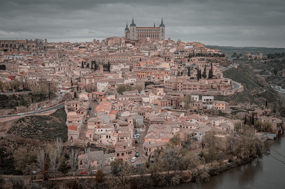
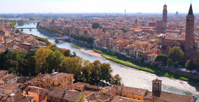
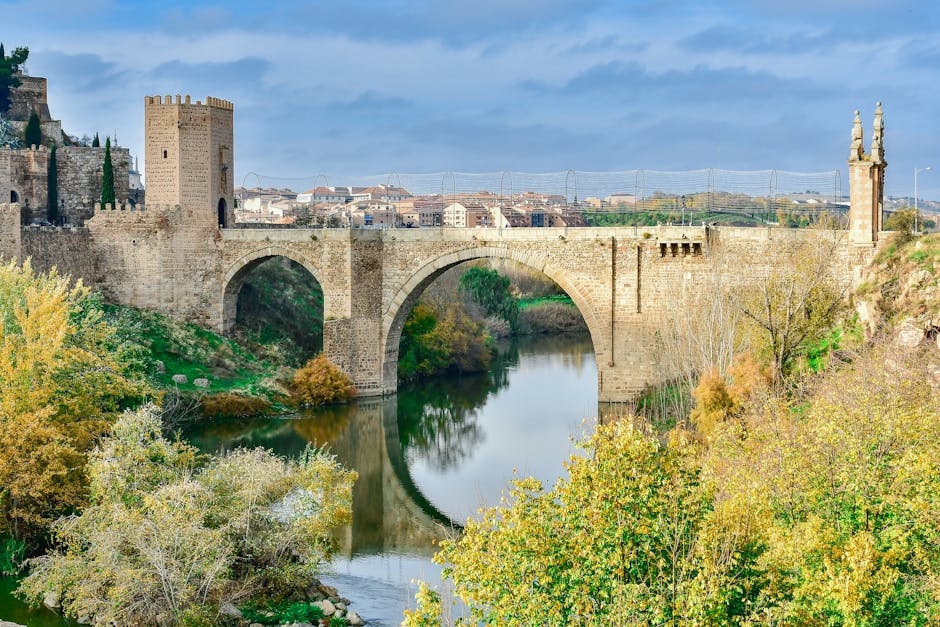
1. Senda Ecológica del Tajo — Urban riverside loop (Toledo city centre)
Distance: about 6.5 km (loop). Duration: 2–3 hours at an easy pace. Elevation gain: low (±80 m). Difficulty: easy. Recommended start: Puente de San Martín, Calle de la Vida, 45002 Toledo.
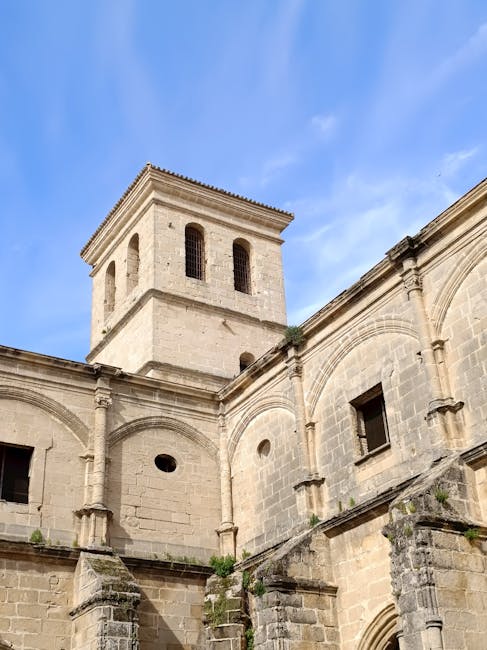
Description: This loop follows the north bank of the Tagus before returning via trails and stairways that lead to Toledo’s historic viewpoints. It’s ideal for combining panoramic city views, photo stops and a touch of nature right next to the centre. The route begins at the Puente de San Martín (Ponte San Martín), a medieval bridge at the city’s western entrance, near Paseo del Miradero, 45002 Toledo, within easy walking distance from the historic core.
From there, the Senda Ecológica takes wide tracks and dirt paths along the river, offering sights of the Monasterio de San Juan de los Reyes and the cathedral’s imposing silhouette in the distance. The route then reaches the Mirador del Valle (access via Calle Rosa, 45002 Toledo), a must-visit viewpoint for sunset photos. The stairs and sloping paths are short and well maintained — this loop is suitable for off-road strollers and casual cyclists.
Hours and fees: the Senda Ecológica is free and open 24/7. Parking: public free and paid parking is available around the bridge and on nearby streets (regulated zones as indicated by signs). Practical tips: bring sunglasses and a water bottle; in summer start early or late afternoon to avoid the heat. Public toilets: available near Puente de San Martín and at the Plaza de Toros (Calle Toledo, 45002 Toledo).
Local tips: for a fuller experience, combine the loop with a quick visit to the Castillo de San Servando (Paseo del Miradero, s/n, 45002 Toledo) — exterior access is often free; the interior is sometimes used for events, so check opening times. Photography: bring a mid-telephoto lens to capture architectural details on the opposite hill.
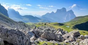
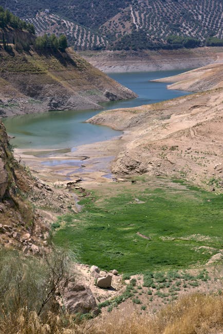
2. Mirador y Barrancas de Burujón — Cliffs and clay canyons loop
Distance: 5–7 km depending on variants. Duration: 2–3 hours. Elevation gain: moderate (±150 m). Difficulty: easy to moderate. Starting point: Plaza del Ayuntamiento, 1, 45540 Burujón, Toledo.
Description: The Barrancas de Burujón are a spectacular set of clay erosions forming ochre-red cliffs that overlook the calm waters of the Castrejón reservoir (Embalse de Castrejón). The loop starts in the village of Burujón (Plaza del Ayuntamiento, 1, 45540 Burujón), a peaceful village about 35 km northwest of Toledo — roughly a 30–40 minute drive.
The trail runs along marked paths with dizzying viewpoints over the « barrancas. » The main track is well defined: alternating panoramic ridges and flat sections where you can spot thermophilous plants (rosemary, thyme) and water birds near the reservoir. Observation areas are safe but not fenced — watch children closely. The route can be shortened to a one-hour walk or extended to reach quieter overlooks.
Hours and fees: free access. Parking: free public parking at the starting plaza; in high season the village can get busy — arrive early. Services: small bar/restaurant « Bar Restaurante El Mirador », Calle Real, s/n, 45540 Burujón — typical hours 09:00–23:00, dishes from about €8.
Local tips: wear shoes with good grip; some clay sections get slippery after rain. Bring a windbreaker: the area is exposed and temperatures can drop quickly late in the day. Birdwatching: spotting scopes recommended to see herons, storks and raptors. For photographers, the golden hours (sunrise/sunset) bring out striking colors on the clay and water.
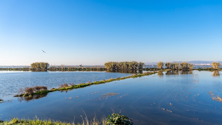
3. Lagunas de Villafranca de los Caballeros — Lagoon and salt-flat loop
Distance: 6–8 km. Duration: 2–3 hours. Elevation gain: very low. Difficulty: easy, flat terrain. Starting point: Tourist Office, Plaza de la Constitución, 1, 45760 Villafranca de los Caballeros, Toledo.
Description: The lagoons near Villafranca de los Caballeros form a semi-natural wetland mosaic important for migratory birds. The route begins at the Villafranca Tourist Office (Plaza de la Constitución, 1, 45760), where panels explain the lagoons’ geology and local species. The loop follows farm tracks and prepared dirt paths, with birdwatching hides for safe observation of flamingos, sandpipers, coots and waterfowl.
Because the ground is often marshy, parts of the loop use wooden boardwalks and reinforced banks. The scenery changes with the seasons: abundant spring water favors nesting, while salt flats are more exposed in summer. It’s a quiet spot ideal for nature photography and a contemplative walk.
Hours and fees: free access. Tourist office opening times generally 10:00–14:00 and 17:00–19:00 (seasonal; phone: +34 925 27 80 12 — check before you go). Parking: free spaces on Plaza de la Constitución and adjacent streets. Services: cafés and local shops on the square; a municipal market on certain days.
Local tips: bring binoculars and a bird guide if you can; stick to marked paths to avoid disturbing nesting colonies. Waterproof shoes recommended in wet season. In summer, bring insect repellent. The flat terrain makes the loop very bike-friendly for casual cyclists. Ask the Tourist Office about guided outings — some run for a small fee (around €3–5 per person) during migration periods.
4. Monasterio de Santa María de Melque — Cultural and nature loop
Distance: 4–6 km. Duration: 2 hours. Elevation gain: low. Difficulty: easy. Starting point: Monasterio de Santa María de Melque, Carretera N-401, km 59, 45589 San Martín de Montalbán, Toledo.
Description: The Monasterio de Santa María de Melque is an exceptional Visigothic complex set in open countryside, surrounded by fields and low hills perfect for a peaceful walk. The loop starts around the monastery area (address: Carretera N-401, km 59, 45589 San Martín de Montalbán) and skirts the ruins along farm tracks that offer great views of the architecture and the Castilian rural landscape.
The route includes shaded stretches under scattered trees, spots to watch rural wildlife and dry stone walls that reflect traditional land use. The monastery itself is worth a visit: towers and nave are visible from outside for free; the interior is sometimes open to the public through guided visits or scheduled openings managed by the Diputación de Toledo.
Hours and fees: exterior access is free 24/7. Guided visits and interior access: check with the San Martín de Montalbán Tourist Office (Plaza Mayor, s/n, 45589); typical site hours 10:00–18:00 in high season. Price: site entry/guided visits are often free or by suggested donation (€0–3 depending on local organisation). Parking: free parking area at the site entrance.
Local tips: bring water and closed shoes — some tracks are stony. Interpretation: multilingual panels near the monastery. Photography: morning or late afternoon light flatters the pale stone. If you want to extend the outing, the small village of San Martín de Montalbán has rustic bars and restaurants (for example « Mesón El Molino », Calle Real, s/n; hours 12:00–16:00 and 20:00–23:00).
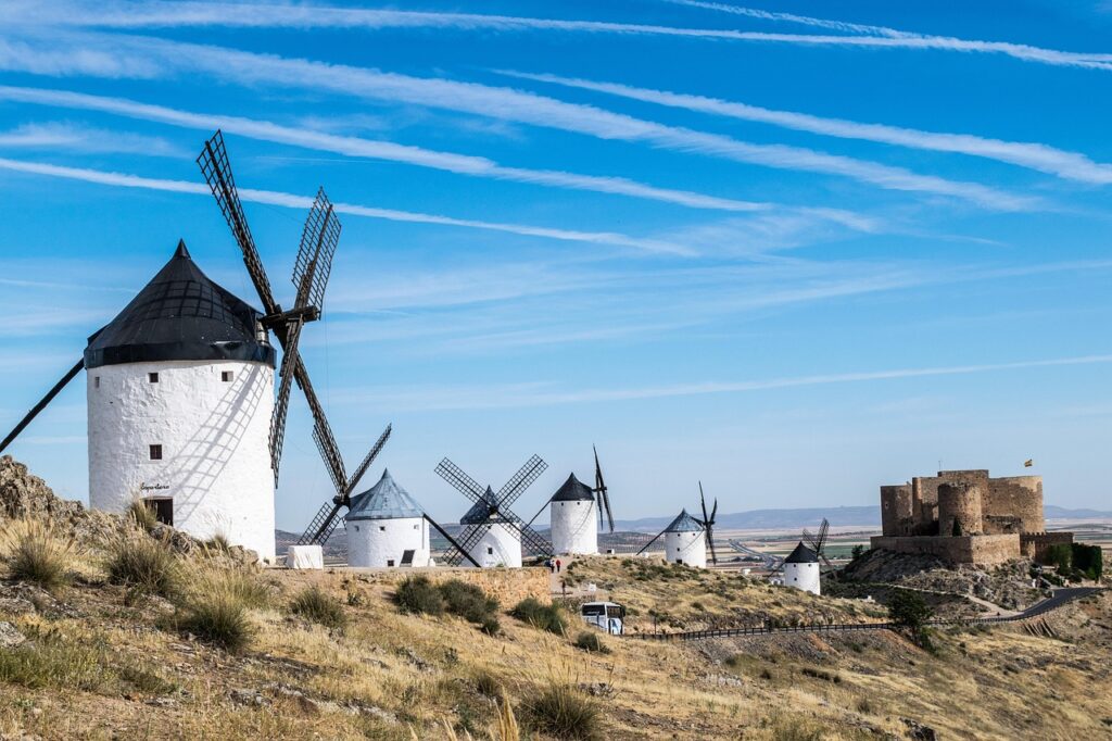
5. Consuegra — Windmills and Cerro Calderico loop
Distance: 5–7 km depending on variants. Duration: 2–3 hours. Elevation gain: moderate (hills). Difficulty: easy. Starting point: Plaza de España, 45880 Consuegra, Toledo.
Description: About 70 km southeast of Toledo, the town of Consuegra is famous for its line of windmills on the Cerro Calderico. This loop blends heritage and landscape: start from Plaza de España (45880 Consuegra) and climb Cerro Calderico to circle the windmills and the fortified Castillo de Consuegra. The trail alternates stony paths and grassy tracks, easy to follow thanks to tourist waymarking.
The view from Cerro Calderico sweeps across the La Mancha plain, with perfect panoramas at sunrise and sunset. The route can include a descent through olive groves and a short detour to the castle’s old patrol path. It’s a cultural walk that will delight Don Quixote fans: these windmills are often linked to scenes from Cervantes’ novel.
Hours and fees: access to the windmills is free; some mills and the Castillo de Consuegra open to visitors with variable hours — generally 10:00–14:00 and 16:00–19:00; combined windmill + castle ticket: around €3–4 (indicative prices, check with the Consuegra Tourist Office, Plaza de España, 45880; phone +34 925 46 82 01). Parking: public spaces around Plaza de España and nearby car parks.
Local tips: wear light hiking shoes for the climb; bring a windproof jacket as the hilltops are exposed. Carry water, especially in summer. For a tasty post-walk treat, try local specialties (gachas, manchego cheese) in the bars on Plaza de España. Photography: classic shots pair a windmill in the foreground with the castle in the background for iconic images.
Conclusion
These five easy loops around Toledo offer a wide range of experiences: from a riverside stroll along the Tagus to the lunar-like landscapes of the Barrancas de Burujón, from bird-rich wetlands to isolated historic sites like Santa María de Melque, and the legendary windmills of Consuegra. Each can be completed in a half-day, making them perfect for time-pressed travelers or for those wanting to add a nature escape to a cultural visit of Toledo.
Plan your outing with the seasons in mind: spring and autumn bring ideal temperatures and pleasant colors; in summer adjust timing (early morning or late afternoon) and increase hydration and sun protection. In winter, check the accessibility of secondary roads and the local weather. For families choose the flattest loops (Senda Ecológica del Tajo, Lagunas de Villafranca); photographers should favor Burujón and Consuegra at the golden hours. For every route, respect the environment and local rules: don’t leave rubbish, stay on marked trails and follow signage.
Finally, remember that welcoming rural communities lie behind these landscapes: small cafés for a break, local tourist offices for maps and up-to-date info, and artisans selling local products (cheeses, honey, olive oil). These easy hikes let you not only admire the views but also feel the pulse of Castilla–La Mancha — a blend of silence, history and hospitality. Happy hiking and enjoy the natural and cultural treasures around Toledo.